The lands of the empire
204 provinces and kingdoms, from Britain to Mesopotamia: their peoples, cities, government and fate.
About this compendium
Republic · Principate · Late Empire · Eastern Roman Continuity
Rome’s provinces were inhabited societies before they were coloured territories on a map. Their histories include the peoples and kingdoms that preceded conquest, the circumstances of annexation, the work of government, the movement of armies and merchants, the organization of land and labour, religious change, urban life, rebellion, and the emergence of new political orders.
This atlas follows those histories from the first overseas acquisitions through the transformations of late antiquity. The principal dossiers trace large provincial histories in depth. The later provincial profiles give separate identities to the smaller jurisdictions created by subdivision. Further dossiers distinguish Republican commands, temporary arrangements, sixth-century reforms, and restored imperial territories.
Dates use BCE and CE; c. indicates an approximation. A conquest date, the appointment of a governor, a fiscal reform, a subdivision, and the loss of effective control can be different events. Modern place names are locators, not equivalents for ancient boundaries. Where a capital, date, or territorial identification remains uncertain, that uncertainty is part of the historical description.
City gazetteers identify settlements associated with each regional history across time. Their placement does not assert that every settlement held the same civic status or belonged to the same province in every century. In the eastern campaign districts, inclusion can indicate Roman military activity rather than settled provincial government.
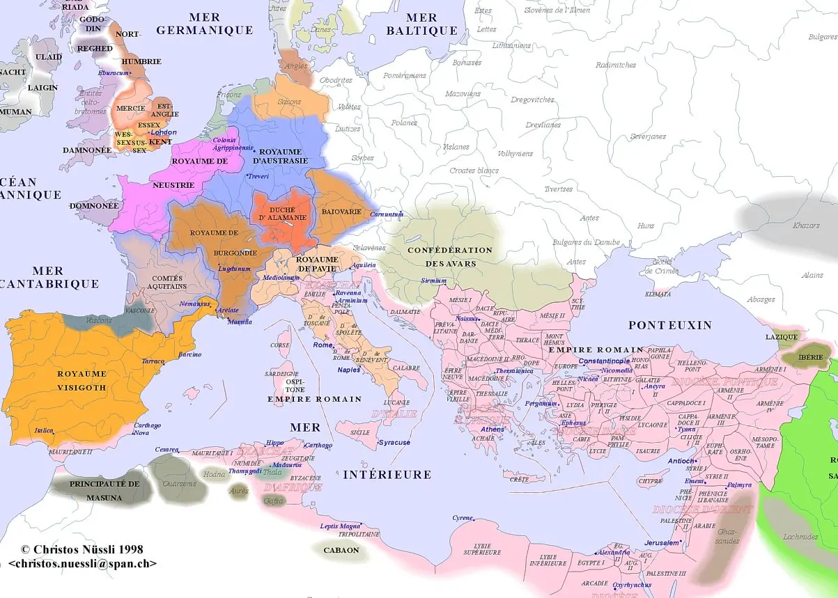
Maps depict particular periods or successive layers of change. Campaign arrows summarize movements, and schematic boundaries provide orientation; neither should be read as proof of continuous occupation or surveyed administrative limits. Each caption identifies the historical setting needed to read the plate.
Also: Figures · Wars · Legions · The guides ↓

Italia and the central Mediterranean 4
The Italian peninsula was the political centre from which Rome’s provincial system expanded. The islands surrounding it became essential to food supply and maritime movement, while northern Italy passed from contested command to incorporation within Italy itself.
- ITALIARP-00RP-00
Italia
Italy’s physical diversity shaped the Roman state before Rome governed overseas. The fertile plains of Campania, the river valleys of…
- SICILIARP-01RP-01
Sicilia
Sicily’s location placed it between the Italian peninsula, Africa, and the Greek maritime world. Its coastal plains and interior grain…
- SARDINIA ET CORSICARP-02RP-02
Sardinia et Corsica
Sardinia combined productive plains, mineral-bearing districts, rugged interior uplands, and coastal settlements facing different…
- GALLIA CISALPINARP-03RP-03
Gallia Cisalpina
The Po valley was one of the most productive landscapes acquired by Rome. Broad alluvial plains, tributary rivers, mountain outlets, and…
Hispania 4
Iberia’s provincial history unfolded across Mediterranean cities, southern river valleys, central plateaus, Atlantic districts, and northern mountains. The distinction between a military acquisition and a stable jurisdiction is especially important in a conquest extending over two centuries.
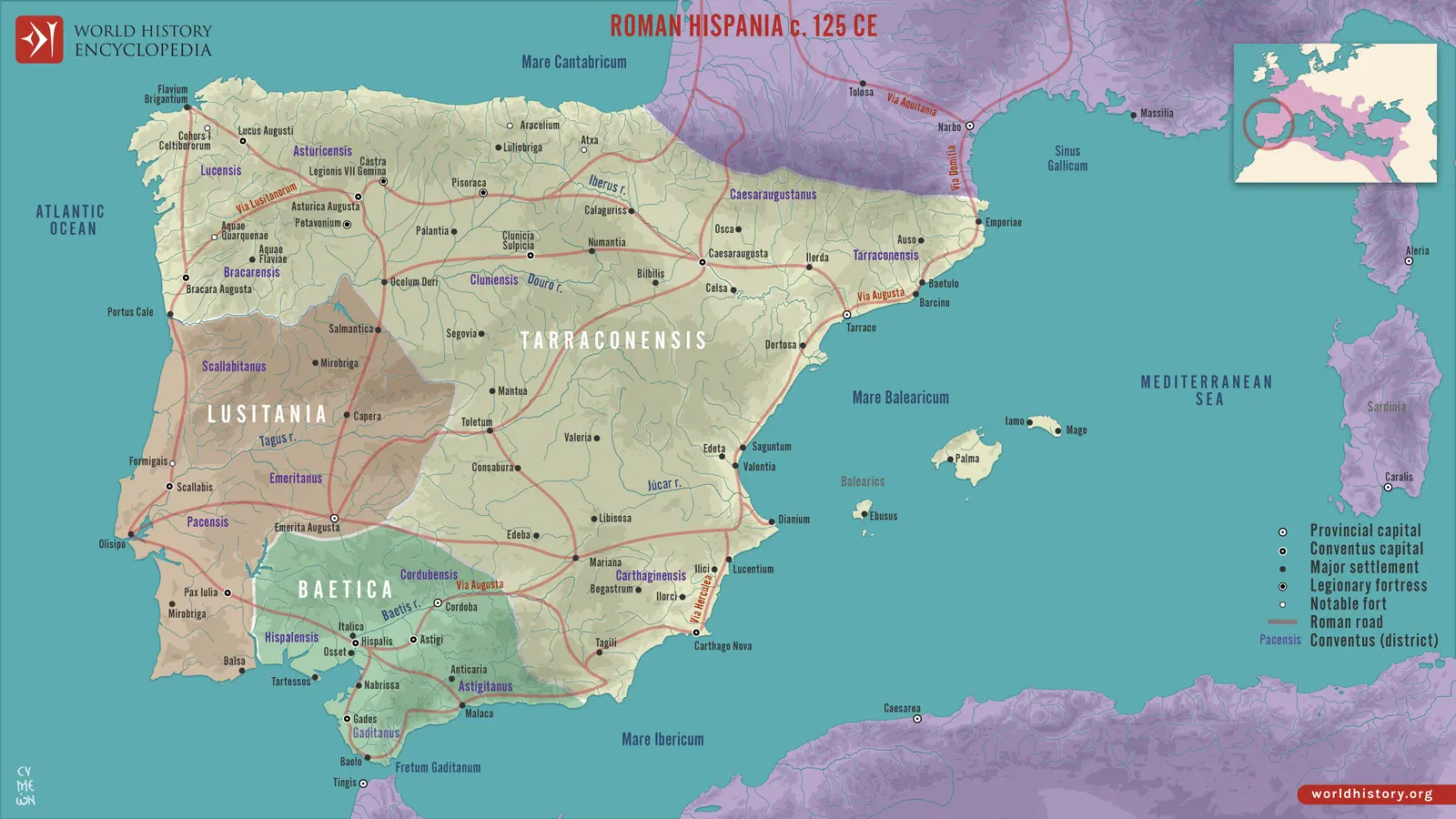
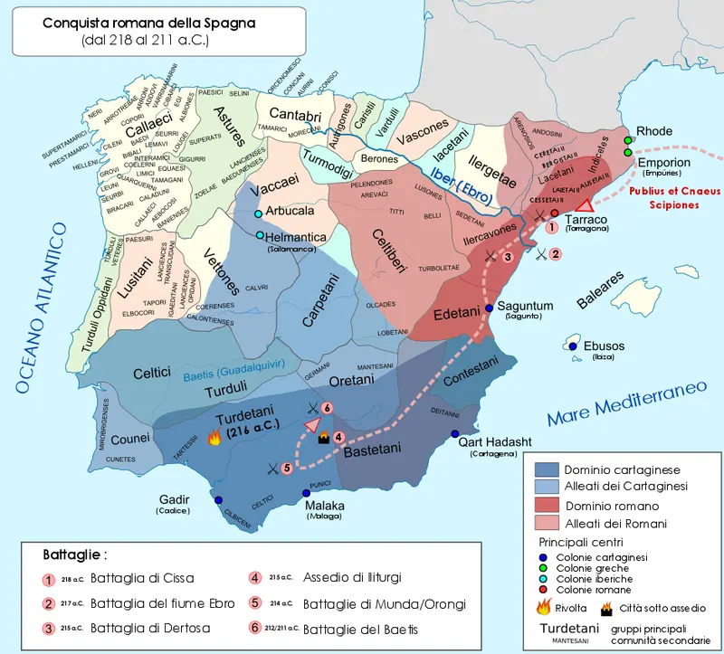 RP-04
Hispania Citerior and Hispania Ulterior
Roman Spain began as a theatre of war against Carthage. Coastal footholds, allied communities, and access to mineral and agricultural…
- HISPANIA BAETICARP-05RP-05
Hispania Baetica
Baetica’s core was the Guadalquivir basin, where river transport connected inland production with estuarine and maritime exchange. The…
- LVSITANIARP-06RP-06
Lusitania
Lusitania crossed landscapes that modern political borders divide differently. Its Atlantic coast opened towards maritime exchange, while…
- HISPANIA CITERIOR TARRACONENSISRP-07RP-07
Hispania Citerior Tarraconensis
Tarraconensis joined regions with very different relationships to Rome. Its Mediterranean cities had long participated in maritime…
Gaul and the Rhine 7
Gaul and the Rhine joined old civic territories, new Roman towns, Mediterranean connections, Atlantic and Channel routes, and heavily defended frontier sectors. The same region could be a productive civilian province, an army-supply hinterland, and a theatre of imperial civil war.
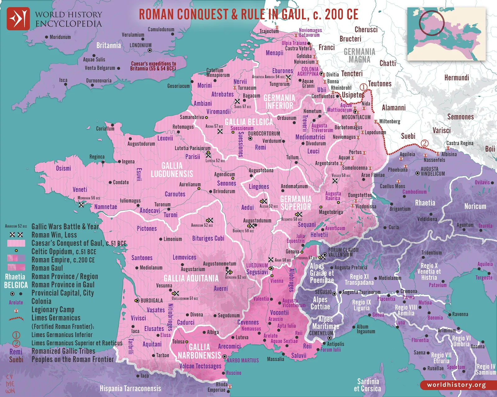
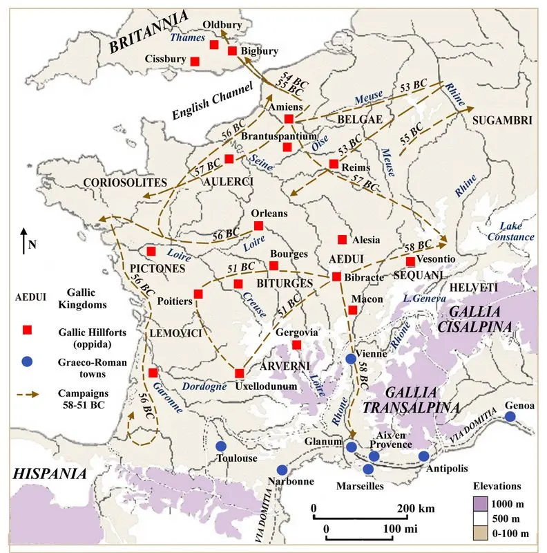
- GALLIA NARBONENSISRP-08RP-08
Gallia Narbonensis
Narbonensis was the original Roman bridge across southern Gaul. Its Mediterranean coast, lower Rhône valley, and routes towards the…
- GALLIA AQVITANIARP-09RP-09
Gallia Aquitania
The imperial Aquitania crossed the boundary between the narrower Aquitanian zone south of the Garonne and Celtic-speaking communities…
- GALLIA LVGDVNENSISRP-10RP-10
Gallia Lugdunensis
Lugdunensis extended from the strategic confluence at Lyon across central and northwestern Gaul. It included communities whose access to…
- GALLIA BELGICARP-11RP-11
Gallia Belgica
Belgica connected the Paris basin and northern Gaul to the Rhine and North Sea. Its settlements ranged from inland civic centres to coastal…
- GERMANIA SVPERIORRP-12RP-12
Germania Superior
Germania Superior was more than a strip of forts beside the Rhine. Its jurisdiction included agricultural hinterlands, towns, roads, and…
- GERMANIA INFERIORRP-13RP-13
Germania Inferior
Germania Inferior followed the lower Rhine towards its delta, where waterways, marshes, river islands, and coastal connections mattered as…
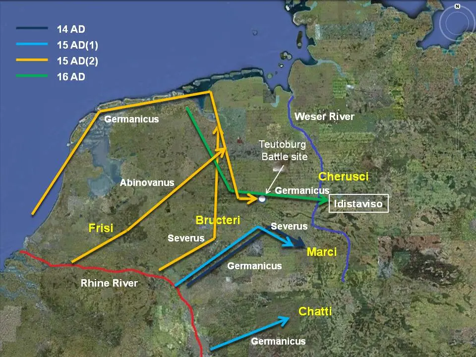 RP-14
The Augustan Germania beyond the Rhine
Augustan campaigns beyond the Rhine sought to reshape the strategic geography of northern Europe. Moving the frontier eastward might reduce…
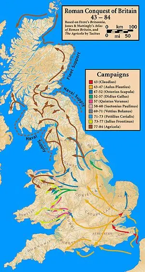
Britannia 1
Britain was a large and expensive military province whose occupation changed substantially over nearly four centuries. Its southern towns, western and northern garrisons, rural districts, mineral resources, and cross-Channel connections formed several overlapping provincial worlds.
The Alps and the Danube 10
The Alpine passes and Danubian river systems linked Italy, central Europe, the Balkans, and the Black Sea. Roads, forts, colonies, mines, fields, markets, and communities sustained an inhabited frontier rather than a single unbroken wall.
- ALPES MARITIMAERP-16RP-16
Alpes Maritimae
Alpes Maritimae controlled the transition between Mediterranean shorelands and the southern Alps. Short distances could involve steep…
- ALPES COTTIAERP-17RP-17
Alpes Cottiae
The Cottian Alps illustrate Roman expansion through an agreement with a local dynasty. Cottius’s relationship with Augustus preserved…
- ALPES GRAIAE ET POENINAERP-18RP-18
Alpes Graiae et Poeninae
The Graian and Poenine districts controlled different but related mountain corridors. The Little St Bernard connected the Aosta region with…
- RAETIARP-19RP-19
Raetia
Raetia joined mountain valleys to northern forelands and river frontiers. The conquered peoples and districts were not all identical with…
- NORICVMRP-20RP-20
Noricum
Noricum’s relationship with Rome developed before direct annexation through trade, diplomacy, and the interests of a regional monarchy. Its…
- ILLYRICVM AND DALMATIARP-21RP-21
Illyricum and Dalmatia
Dalmatia’s Roman territory extended from Adriatic ports across mountain barriers into a large interior. The Dinaric landscape encouraged…
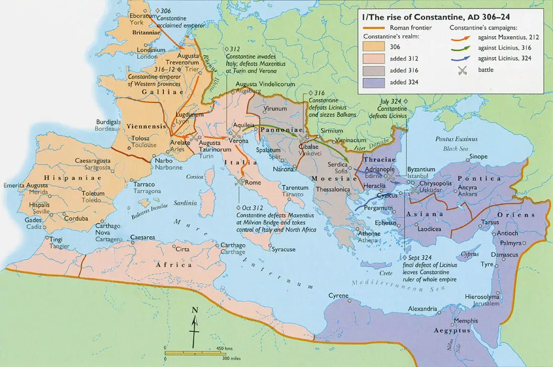 RP-22
Pannonia: Superior, Inferior, and their successors
Pannonia joined the Danube frontier to the Sava and Drava basins and the approaches towards Italy. Its plains, river valleys, marshlands…
- MOESIARP-23RP-23
Moesia: Superior, Inferior, and their successors
Moesia connected the upper Balkan interior with the lower Danube and Black Sea. Its river crossings, fertile plains, mountain approaches…
- TRAJANIC DACIA AND THE THREE DACIASRP-24RP-24
Trajanic Dacia and the Three Dacias
Dacia’s preconquest political centre lay within a landscape of mountains, uplands, fortified sites, and routes across the Carpathian…
- DACIA AVRELIANA, RIPENSIS, AND MEDITERRANEARP-25RP-25
Dacia Aureliana, Ripensis, and Mediterranea
Dacia Aureliana preserved the name of a lost province within the empire’s remaining Balkan territory. The act expressed continuity of Roman…
Macedonia, Greece, Epirus, and Thrace 4
The southern Balkans connected the Adriatic, Aegean, Danube approaches, and imperial straits. Older kingdoms and Greek civic communities became Roman jurisdictions, then smaller Christian provinces in a region whose political importance grew with Constantinople.
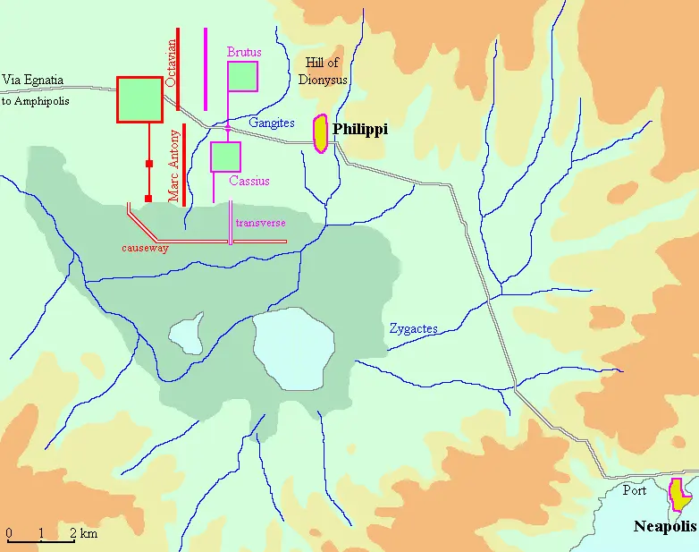 RP-26
Macedonia
Macedonia’s provincial history began with the dismantling of a monarchy whose military and political traditions had shaped the eastern…
- ACHAIARP-27RP-27
Achaia
Achaia joined landscapes with exceptionally strong civic memories: Athens, Sparta, Corinth, the Peloponnesian cities, central Greek…
- EPIRVS, EPIRVS VETVS, AND EPIRVS NOVARP-28RP-28
Epirus, Epirus Vetus, and Epirus Nova
Epirus occupied a landscape of coastal plains, river mouths, rugged uplands, and passes. Its communities had long participated in Greek and…
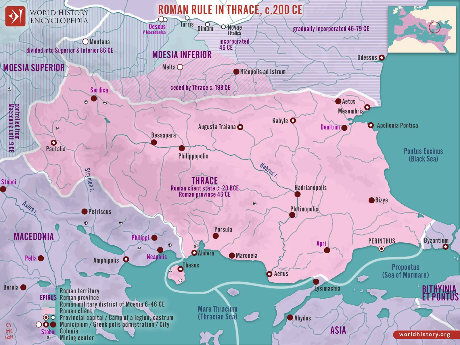 RP-29
Thracia
Thracia’s pre-annexation history included several royal arrangements, local communities, and relationships with Rome. Its plains and river…
Anatolia and the Aegean 8
Anatolia’s provincial history combined dense Greek city networks, older regional traditions, plateau routes, client kingdoms, mountain corridors, and eastern frontier commands. Its provinces remained culturally varied under a common imperial sovereignty.
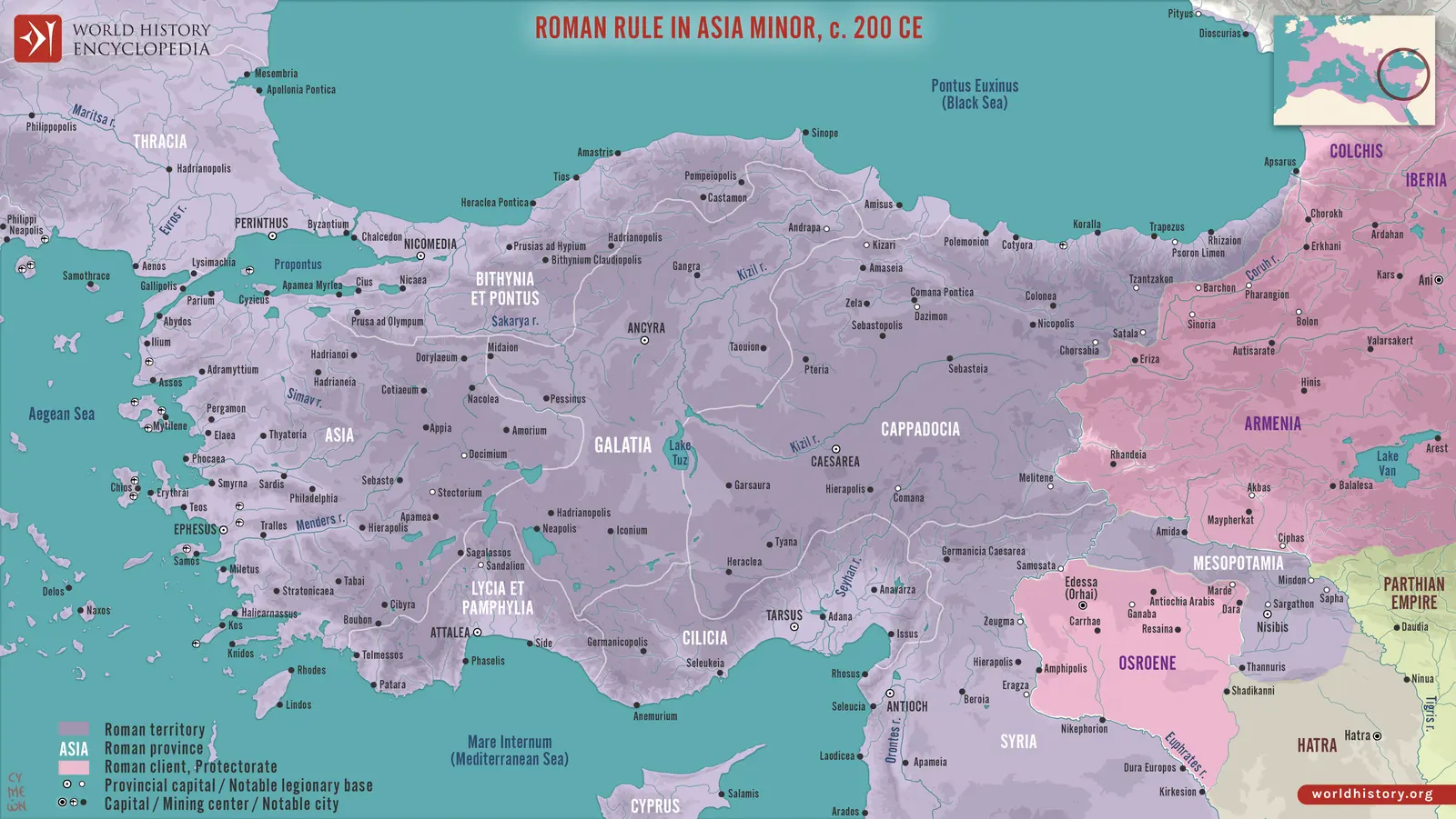
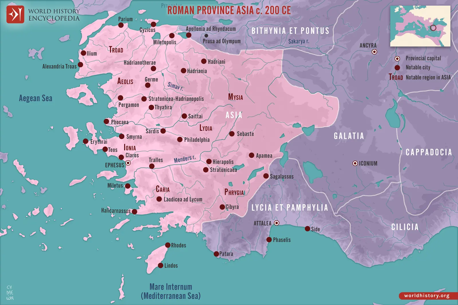 RP-30
Asia
Asia was a Roman province built upon a dense Hellenistic urban world. Its cities possessed councils, assemblies, sanctuaries, festivals…
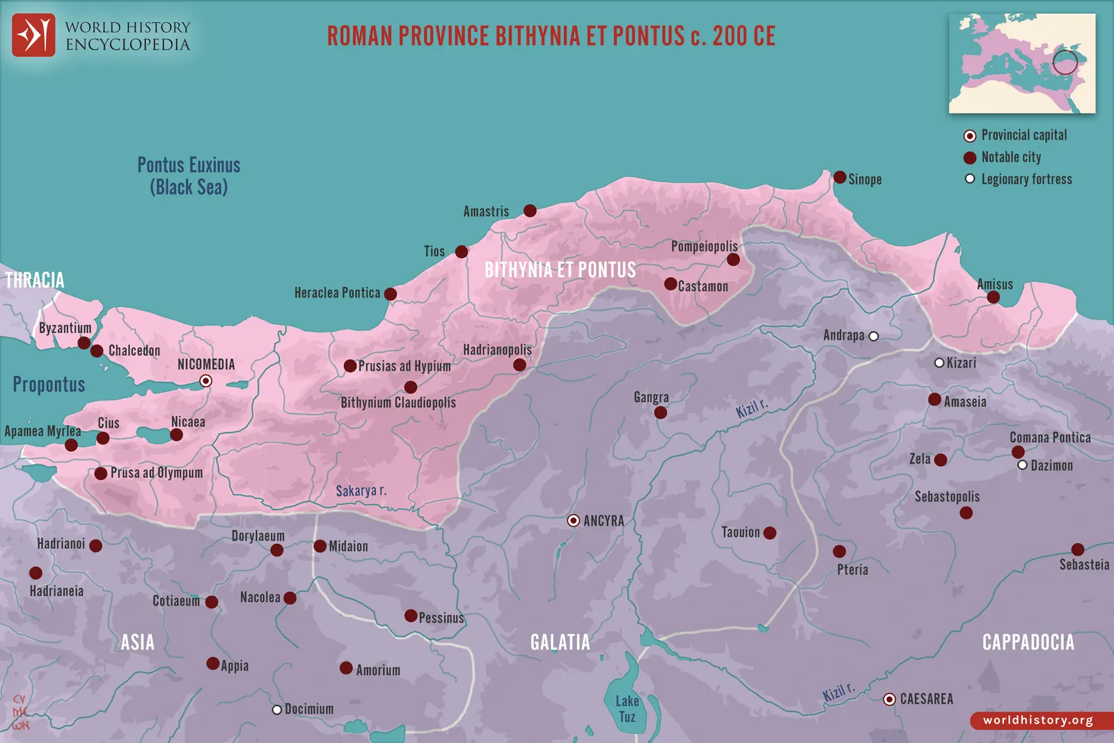 RP-31
Bithynia et Pontus
Bithynia had a royal history distinct from the Pontic kingdom of Mithridates VI. Nicomedes IV’s bequest brought the former kingdom into…
- GALATIARP-32RP-32
Galatia
The Galatians originated in Celtic-speaking groups that entered Anatolia during the Hellenistic period. Their eventual territories and…
- CAPPADOCIARP-33RP-33
Cappadocia
Cappadocia’s uplands, valleys, volcanic landscapes, and routes towards Armenia made it strategically valuable before annexation. Its…
- CILICIARP-34RP-34
Cilicia
Cilicia contained a sharp contrast between the fertile eastern plain and the rougher western coast and mountain districts. The Taurus…
- LYCIA ET PAMPHYLIARP-35RP-35
Lycia et Pamphylia
Lycia possessed a distinctive civic and regional organization before direct annexation. Its cities, sanctuaries, tombs, and…
- CYPRVSRP-36RP-36
Cyprus
Cyprus’s position made it accessible from Anatolia, the Levant, and Egypt. Its central plain, mountain districts, productive valleys, and…
- CRETA ET CYRENAICARP-37RP-37
Creta et Cyrenaica
Crete contained mountain interiors, productive plains, numerous cities, and harbours oriented towards several parts of the Mediterranean.…
The Levant and eastern borderlands 7
The eastern borderlands required repeated choices between annexation, client rule, military occupation, and negotiated frontiers. Cities and communities continued across political changes that could rapidly transform provincial boundaries and relationships with neighbouring powers.
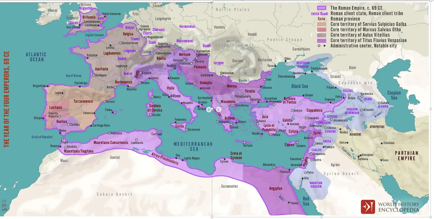 RP-38
Syria, Syria Coele, and Syria Phoenice
Syria was a landscape of coastal cities, river valleys, cultivated plains, mountain zones, oases, and desert approaches. Greek-speaking…
- JVDAEA AND SYRIA PALAESTINARP-39RP-39
Judaea and Syria Palaestina
Judaea’s provincial history emerged from the world of Hasmonean kingship, Roman intervention, and Herodian monarchy. Pompey’s capture of…
- ARABIA PETRAEARP-40RP-40
Arabia Petraea
Arabia’s Roman province emerged from a kingdom whose power rested on cities, regional agriculture, water management, trade routes, and…
- ARMENIARP-41RP-41
Armenia: annexation, withdrawal, and the later Roman provinces
Armenia’s highlands, valleys, mountain routes, and aristocratic structures made it a major power between larger empires. Kingship depended…
- MESOPOTAMIARP-42RP-42
Mesopotamia
The Roman provincial name covered only part of a much larger geographical Mesopotamia. Northern plains, river valleys, mountain approaches…
- OSROENE / OSRHOENERP-43RP-43
Osroene / Osrhoene
Osroene’s political centre at Edessa occupied a valuable position near routes between the Euphrates, northern Mesopotamia, and the…
- ASSYRIA AND TRAJAN’S DISPVTED EASTERN PROVINCERP-44RP-44
Assyria and Trajan’s disputed eastern province
Assyria carried a deep historical and geographical inheritance before Trajan’s campaigns. Greek and Roman writers could use the term for…
Egypt and Roman Africa 5
Egypt’s Nile system and North Africa’s varied coastal and inland landscapes supplied food, revenues, manufactured goods, soldiers, and major religious and intellectual traditions. Their histories include both enduring regional structures and profound episodes of conquest, division, and recovery.
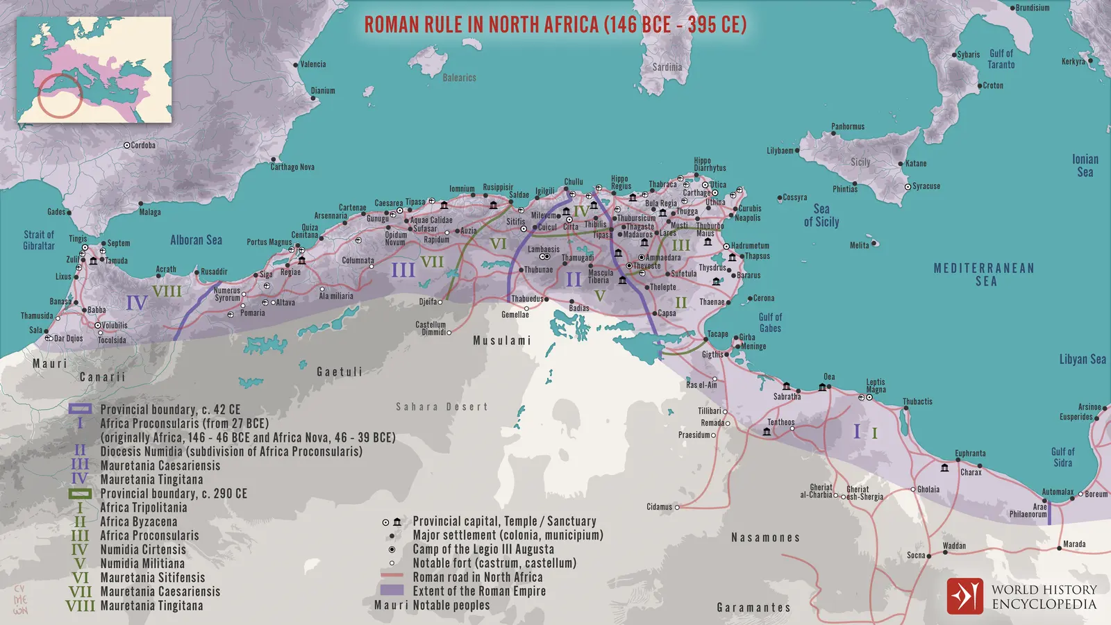
- AEGYPTVSRP-45RP-45
Aegyptus
Egypt’s Roman history began with the conquest of an exceptionally old and organized society. The Nile flood, canals, embankments, fields…
- AFRICA VETVS, AFRICA NOVA, AND AFRICA PROCONSVLARISRP-46RP-46
Africa Vetus, Africa Nova, and Africa Proconsularis
Roman Africa began in the destruction of a major rival. Carthage’s fall in 146 BCE brought devastation and a new provincial claim over part…
- NVMIDIARP-47RP-47
Numidia
Numidia’s history begins with kingdoms and regional societies rather than a ready-made Roman province. Masinissa’s alliance with Rome…
- MAVRETANIA CAESARIENSISRP-48RP-48
Mauretania Caesariensis
Mauretania’s monarchy under Juba II and Ptolemy connected North African societies to Rome through dynastic alliance, elite culture, and…
- MAVRETANIA TINGITANARP-49RP-49
Mauretania Tingitana
Tingitana faced the Atlantic and the Strait of Gibraltar, with mountain and inland districts connected to coastal towns through routes of…
The later western provinces 59
The late third and fourth centuries replaced many large commands with smaller civil jurisdictions. Their governors administered justice, taxation, public obligations, and relations with cities, while military command increasingly followed a separate structure. The following profiles describe the provinces of the late fourth- and early fifth-century administrative world. Their territories and effective control were not all stable at one moment.
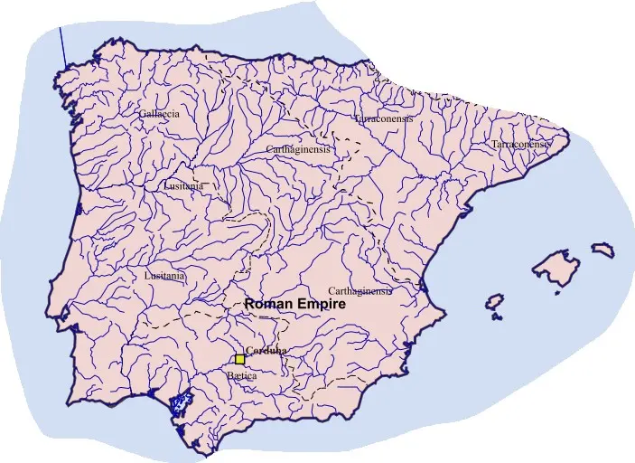
- BAETICALW-01LW-01
Baetica
Late Baetica retained its recognizable identity within the Diocese of Hispania. Its Guadalquivir-centred agriculture, cities, estates, and…
- LVSITANIALW-02LW-02
Lusitania
Lusitania remained a separate late province with a strong administrative and religious centre at Emerita. Its territory joined Atlantic and…
- GALLAECIALW-03LW-03
Gallaecia
Gallaecia combined Atlantic districts, interior uplands, mining landscapes, and important road systems. Its cities had developed from the…
- TARRACONENSISLW-04LW-04
Tarraconensis
Late Tarraconensis retained a Mediterranean focus while losing extensive southern and northwestern territories to new jurisdictions.…
- CARTHAGINIENSISLW-05LW-05
Carthaginiensis
Carthaginiensis joined Mediterranean ports with inland plateaus and routes. Its creation placed civil administration closer to territories…
- INSVLAE BALEARESLW-06LW-06
Insulae Baleares
The island province depended on shipping for administration, commerce, and defence. Farming, livestock, local production, and Mediterranean…
- MAVRETANIA TINGITANALW-07LW-07
Mauretania Tingitana
Late Tingitana occupied a contracted official territory compared with the earlier province. Withdrawal from some interior districts did not…
- BELGICA PRIMALW-08LW-08
Belgica Prima
Belgica Prima’s importance was amplified by Trier’s role as an imperial residence and administrative centre. Court activity, military…
- BELGICA SECVNDALW-09LW-09
Belgica Secunda
The province connected productive agricultural districts, civic centres, roads towards the Channel, and routes to the northeastern…
- GERMANIA PRIMALW-10LW-10
Germania Prima
The province governed a reduced frontier landscape after the loss of the eastern salient. River crossings, fortified towns, agricultural…
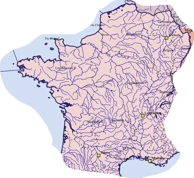 LW-11
Germania Secunda
The lower river remained a route for military transport, commerce, and communication. Cologne’s urban institutions and Christian community…
- LVGDVNENSIS PRIMALW-12LW-12
Lugdunensis Prima
The province retained a city whose transport, commercial, and imperial functions had long exceeded an ordinary local role. The Rhône-Saône…
- LVGDVNENSIS SECVNDALW-13LW-13
Lugdunensis Secunda
The Seine’s lower course and Channel-facing districts gave the province a distinct orientation. Rouen connected inland movement with…
- LVGDVNENSIS TERTIALW-14LW-14
Lugdunensis Tertia
Tours’s river position placed the province within an important western communications system. Its towns and rural territories depended on…
- LVGDVNENSIS SENONIA / QVARTALW-15LW-15
Lugdunensis Senonia / Quarta
The province organized inland districts whose roads and river routes connected the Seine basin and neighbouring regions. Sens’s…
- MAXIMA SEQVANORVMLW-16LW-16
Maxima Sequanorum
This province connected difficult mountain approaches with routes between Gaul, the Rhine, and the Alpine region. Besançon’s position made…
- AQVITANIA PRIMALW-17LW-17
Aquitania Prima
The province’s orientation was more inland than that of Bordeaux-centred Aquitania Secunda. Agricultural districts, towns, roads, and…
- AQVITANIA SECVNDALW-18LW-18
Aquitania Secunda
The Garonne and Atlantic connections shaped this province’s economy. Bordeaux’s commercial and educational prominence brought together…
- NOVEMPOPVLANALW-19LW-19
Novempopulana
The name recalled a group of southwestern peoples and gave administrative expression to a regional identity not dissolved by earlier…
- NARBONENSIS PRIMALW-20LW-20
Narbonensis Prima
The province retained the western coastal and inland routes linking Gaul with Hispania. Narbonne’s harbour system, road junctions, urban…
- NARBONENSIS SECVNDALW-21LW-21
Narbonensis Secunda
The province joined inland towns, cultivated districts, and routes towards the Alps and Rhône. Aix’s administrative role gave an older…
- VIENNENSISLW-22LW-22
Viennensis
River movement, ports, roads, and productive hinterlands made this one of the western empire’s important communications regions. Vienne…
- ALPES MARITIMAELW-23LW-23
Alpes Maritimae
Late Alpes Maritimae covered a different administrative landscape from the earliest coastal-centred arrangements. Mountain roads and valley…
- ALPES GRAIAE ET POENINAELW-24LW-24
Alpes Graiae et Poeninae
The combined late province coordinated routes with different local histories. Passes, river valleys, transport services, pastoral movement…
- BRITANNIA PRIMALW-25LW-25
Britannia Prima
The province emerged from the subdivision of the older British commands. Its exact boundaries are not securely established, and western…
- BRITANNIA SECVNDALW-26LW-26
Britannia Secunda
The name distinguished one of the late civil jurisdictions from its neighbours, but did not simply preserve Britannia Inferior unchanged.…
- MAXIMA CAESARIENSISLW-27LW-27
Maxima Caesariensis
Its consular rank indicates a distinguished late provincial office. London’s commercial, administrative, and transport functions make its…
- FLAVIA CAESARIENSISLW-28LW-28
Flavia Caesariensis
The province’s name and governor belong securely to the late administrative world, while modern attempts to assign a precise central or…
- VALENTIALW-29LW-29
Valentia
Valentia’s creation or restoration commemorated renewed imperial authority. The central uncertainty concerns where it lay and how it…
- VENETIA ET HISTRIALW-30LW-30
Venetia et Histria
The province connected the Adriatic with the routes towards the Alps and Danube. Aquileia’s commerce, public institutions, Christian…
- AEMILIALW-31LW-31
Aemilia
Aemilia’s late provincial identity formalized a region long integrated into Italy. Agricultural wealth, surveyed countryside, roads, towns…
- LIGVRIALW-32LW-32
Liguria
Late Liguria did not correspond simply to the modern coastal region bearing the name. Milan’s position in the northwestern plain and its…
- FLAMINIA ET PICENVM ANNONARIVMLW-33LW-33
Flaminia et Picenum Annonarium
The province’s name connected the Flaminian corridor with a northern Picene jurisdiction distinguished from Picenum Suburbicarium. Roads…
- ALPES COTTIAELW-34LW-34
Alpes Cottiae
Late placement within the Italian administrative sphere reflected the corridor’s relationship to the peninsula. Pass security, transport…
- RAETIA PRIMALW-35LW-35
Raetia Prima
The province emphasized Alpine valleys and approaches rather than the whole older upper Danubian frontier. Farming in suitable districts…
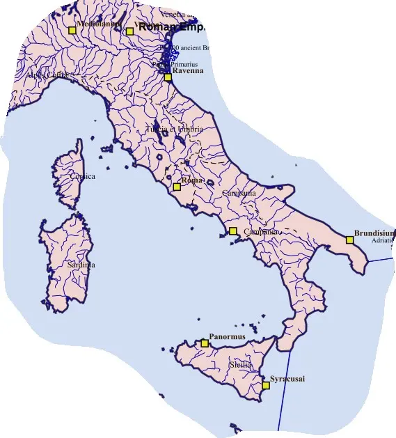 LW-36
Raetia Secunda
The province retained a stronger relationship to the northern foreland, frontier settlements, and Danube communications than Prima.…
- TVSCIA ET VMBRIALW-37LW-37
Tuscia et Umbria
The late province joined regions with deep and distinct pre-Roman histories that had long been incorporated into Italy. Urban councils…
- PICENVM SVBVRBICARIVMLW-38LW-38
Picenum Suburbicarium
Its separate designation distinguished it from the northern Picene districts linked with Flaminia. Coastal towns, inland valleys, roads…
- CAMPANIALW-39LW-39
Campania
Late Campania inherited rich farming districts, ports, villas, workshops, and strong cultural traditions. It was a civil province within…
- SAMNIVMLW-40LW-40
Samnium
The late province revived an old regional name within a new administrative structure. It did not restore the independent Samnite peoples of…
- VALERIA IN ITALYLW-41LW-41
Valeria in Italy
The province organized inland communities, valleys, and mountain routes within the suburbicarian sphere. Its precise territorial…
- APVLIA ET CALABRIALW-42LW-42
Apulia et Calabria
The combined province joined productive plains, pastoral districts, ports, and routes across the heel of Italy. Ancient Calabria in this…
- LVCANIA ET BRVTTIILW-43LW-43
Lucania et Bruttii
The late province combined regions with distinct Greek, Italic, and Roman inheritances. Agriculture, pastoral activity, woodland, local…
- SICILIALW-44LW-44
Sicilia
The island retained its provincial identity and importance to grain supply, maritime movement, and aristocratic landholding. Cities…
- SARDINIALW-45LW-45
Sardinia
Late Sardinia retained important agricultural, maritime, and mineral resources. Coastal towns and inland communities experienced Roman…
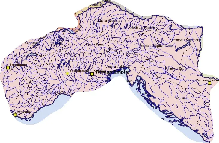 LW-46
Corsica
Corsica’s mountain terrain and limited plains supported a smaller urban framework than Sardinia. Coastal settlements connected it with…
- PANNONIA PRIMALW-47LW-47
Pannonia Prima
The province combined civilian administration with proximity to important Danubian military sectors. Roads linked towns and farming…
- PANNONIA SECVNDALW-48LW-48
Pannonia Secunda
Sirmium’s court, administrative, military, and religious functions gave this province exceptional importance. The Sava corridor and routes…
- SAVIALW-49LW-49
Savia
Savia’s name expressed its relationship to the Sava rather than to a modern national territory. Siscia connected river routes, roads…
- VALERIA IN PANNONIALW-50LW-50
Valeria in Pannonia
Pannonian Valeria occupied a frontier-facing landscape of forts, towns, roads, and productive hinterlands. Civil government and riverine…
- DALMATIALW-51LW-51
Dalmatia
The reduced province retained coastal cities, inland resources, roads, recruitment traditions, and Christian institutions. Salona remained…
- NORICVM RIPENSELW-52LW-52
Noricum Ripense
The province’s identity rested on the river frontier, military establishments, transport, and the agricultural communities supporting them.…
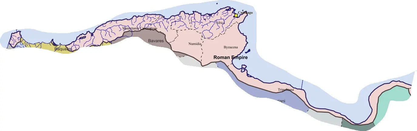 LW-53
Noricum Mediterraneum
The interior province connected Alpine valleys, productive districts, and routes towards Italy and the Danube. Its economy included…
- AFRICA PROCONSVLARIS / ZEVGITANALW-54LW-54
Africa Proconsularis / Zeugitana
The province retained a governor of exceptional rank and a city whose scale, revenues, port, religious institutions, and economic…
- BYZACENALW-55LW-55
Byzacena
Byzacena contained a dense network of towns, farms, estates, presses, and routes linking productive countryside with Mediterranean ports.…
- TRIPOLITANIALW-56LW-56
Tripolitania
The province connected Mediterranean ports with productive hinterlands and desert-edge routes. Farming relied in some districts on careful…
- NVMIDIALW-57LW-57
Numidia
Late Numidia retained the interaction of agricultural towns, military traditions, regional elites, and a strongly developed Christian…
- MAVRETANIA CAESARIENSISLW-58LW-58
Mauretania Caesariensis
The reduced province retained ports, towns, agricultural resources, and a difficult interior political geography. Military security…
- MAVRETANIA SITIFENSISLW-59LW-59
Mauretania Sitifensis
Sitifensis gave a distinct governor to an inland and mountain-adjacent region connected to productive districts and coastal routes.…
The later eastern provinces 61
The eastern provincial system combined smaller civil jurisdictions with older urban networks and a military structure organized for the Danube, Anatolian approaches, and Persian frontier. Provinces bearing ancient geographical names often covered only part of the earlier region. The profiles below follow the administrative world around the late fourth and early fifth centuries, with later changes described where they alter the province’s historical identity.
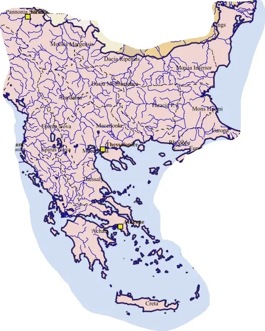
- MACEDONIALE-01LE-01
Macedonia
The province retained a city whose harbour, routes, administration, and Christian institutions gave it significance beyond the size of the…
- ACHAIALE-02LE-02
Achaia
Achaia retained an unusually prestigious title within the smaller provincial system. Corinth’s civil and commercial role differed from…
- THESSALIALE-03LE-03
Thessalia
Thessaly’s broad plains supported cereals, livestock, and established rural communities. Mountain boundaries and passes connected the basin…
- EPIRVS VETVSLE-04LE-04
Epirus Vetus
Nicopolis retained the legacy of Augustus’s victory foundation while becoming an important Christian city. Its coastal connections linked…
- EPIRVS NOVALE-05LE-05
Epirus Nova
Dyrrachium’s port and its position at the western end of the Via Egnatia gave the province a major strategic function. Sea crossings from…
- CRETALE-06LE-06
Creta
The island belonged to the Macedonian diocesan sphere rather than the Egyptian grouping assigned to the Libyan provinces. Its ports…
- MACEDONIA SALVTARIS / SECVNDALE-07LE-07
Macedonia Salutaris / Secunda
The province’s administrative history includes division, reassignment, and territorial relationships with neighbouring jurisdictions. Its…
- DACIA MEDITERRANEALE-08LE-08
Dacia Mediterranea
The province controlled a communications junction between central Balkan routes, Thrace, and the upper Danube approaches. Serdica’s…
- DACIA RIPENSISLE-09LE-09
Dacia Ripensis
The province’s river position made transport, crossings, forts, and army supply central to government. Civil communities supplied the…
- MOESIA PRIMALE-10LE-10
Moesia Prima
The province occupied the strategic approaches near the Sava-Danube confluence and routes into the Balkans. Military establishments, roads…
- DARDANIALE-11LE-11
Dardania
Dardania’s valleys, mineral resources, farming communities, and roads connected the Danubian and Macedonian regions. Scupi’s civic and…
- PRAEVALITANALE-12LE-12
Praevalitana
The province connected coastal routes, inland valleys, productive districts, and Adriatic shipping. Its assignment to the Dacian grouping…
- EVROPALE-13LE-13
Europa
Europa occupied a strategically sensitive landscape near Constantinople. Roads, coastal towns, agriculture, shipping, and the defence of…
- THRACIALE-14LE-14
Thracia
The Maritsa basin and its routes connected productive countryside with towns and military movement. Philippopolis retained major urban and…
- HAEMIMONTVSLE-15LE-15
Haemimontus
The province’s roads and river valleys linked the lower Danube, central Balkans, and straits. Hadrianopolis’s position made it a military…
- RHODOPELE-16LE-16
Rhodope
The province joined difficult uplands with Aegean-facing communications. Farming in suitable districts, livestock, woodland resources…
- MOESIA SECVNDALE-17LE-17
Moesia Secunda
The province retained river-frontier responsibilities and productive hinterlands connected with towns and major roads. Marcianopolis’s…
 LE-18
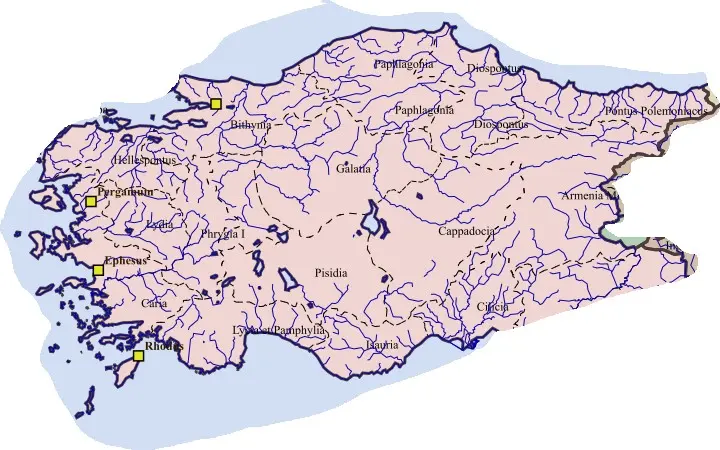
Scythia Minor
The province contained Greek coastal cities, river installations, inland agricultural communities, and strategic crossings. Tomis’s civil…
- ASIALE-19LE-19
Asia
The smaller province inherited only part of the earlier Asia’s territory, but retained strong cities, agriculture, trade, and religious…
- HELLESPONTVSLE-20LE-20
Hellespontus
The province’s ports and crossing routes connected Anatolia with Europe and the Aegean. Agriculture, fisheries, urban crafts, shipping, and…
- LYDIALE-21LE-21
Lydia
Lydia’s name recalled an ancient kingdom and regional identity, but the late province was a Roman civil jurisdiction with its own…
- CARIALE-22LE-22
Caria
The province combined inland valleys, mountain districts, and coastal cities with varied histories. Aphrodisias’s sculpture, civic…
- PHRYGIA PACATIANALE-23LE-23
Phrygia Pacatiana
The province’s valleys and routes linked western Anatolia with inland centres. Farming, livestock, textile traditions, urban manufacture…
- PHRYGIA SALVTARISLE-24LE-24
Phrygia Salutaris
The province connected interior agricultural and pastoral landscapes with roads across Anatolia. Towns, quarries in the wider region, local…
- INSVLAELE-25LE-25
Insulae
The province depended upon maritime communication among islands with distinct civic histories. Harbours, agriculture, local crafts…
- LYCIALE-26LE-26
Lycia
Lycia retained strong local civic histories, league traditions, harbours, and mountain communities. Its late government operated through a…
- PAMPHYLIALE-27LE-27
Pamphylia
The fertile plain, ports, river routes, and Taurus approaches supported agriculture, trade, manufacture, and urban life. The competition…
- PISIDIALE-28LE-28
Pisidia
Pisidia combined uplands, productive basins, towns, routes, and communities with varied pre-Roman histories. Roman colonies and roads had…
- LYCAONIALE-29LE-29
Lycaonia
Lycaonia’s plains, settlements, pastoral resources, and road connections gave it a distinct regional character. Its territories had…
- BITHYNIALE-30LE-30
Bithynia
Nicomedia’s imperial residence and public institutions gave the province exceptional political importance in the Tetrarchic period. Nicaea…
- HONORIASLE-31LE-31
Honorias
The province’s valleys and routes connected inland Anatolia with the Black Sea and western approaches. Farming, woodland resources, local…
- PAPHLAGONIALE-32LE-32
Paphlagonia
Paphlagonia’s mountains, inland basins, roads, and access towards the Black Sea shaped a society of towns, villages, agriculture…
- GALATIALE-33LE-33
Galatia
Ancyra remained an important administrative, religious, and communications centre after the removal of southern and western districts.…
- GALATIA SALVTARISLE-34LE-34
Galatia Salutaris
The province gave Pessinus and its surrounding territories a separate civil identity. The city’s long association with the Great Mother…
- CAPPADOCIA PRIMALE-35LE-35
Cappadocia Prima
The province retained a major urban and Christian centre linked to plateau routes, agricultural districts, estates, and eastern…
- CAPPADOCIA SECVNDALE-36LE-36
Cappadocia Secunda
Tyana’s position near approaches towards the Taurus gave the province an orientation different from the Caesarean core. Agriculture…
- HELENOPONTVSLE-37LE-37
Helenopontus
The province connected inland valleys, towns, cultivated districts, and routes towards the Black Sea. Amaseia’s earlier royal and civic…
- PONTVS POLEMONIACVSLE-38LE-38
Pontus Polemoniacus
The old Polemonian kingdom’s annexation under Nero was an earlier stage, not the creation of an unchanged late province lasting…
- ARMENIA PRIMALE-39LE-39
Armenia Prima
This province belonged to a western frontier landscape long connected with Cappadocian command. It was not the unchanged survival of…
- ARMENIA SECVNDALE-40LE-40
Armenia Secunda
Melitene’s military history and position on eastern routes gave the province a distinctive focus. Agriculture, towns, roads, river…
- SYRIA PRIMALE-41LE-41
Syria Prima
The province retained one of the empire’s great cities, a major military staging area, productive districts, and strong Mediterranean…
- SYRIA SECVNDA / SALVTARISLE-42LE-42
Syria Secunda / Salutaris
The province’s productive countryside and routes supported substantial urban and rural communities. Apamea’s older military, civic, and…
- EVPHRATENSISLE-43LE-43
Euphratensis
Crossings, roads, forts, cultivated districts, and towns made the province essential to communication with Osroene and Mesopotamia.…
- PHOENICELE-44LE-44
Phoenice
Ports, textile and craft traditions, farming, urban institutions, and maritime trade sustained the province. Tyre, Sidon, Berytus, and…
- PHOENICE LIBANILE-45LE-45
Phoenice Libani
The province joined inland cities, valleys, routes, agricultural districts, and mountain approaches. Its name did not make it a purely…
- PALAESTINA PRIMALE-46LE-46
Palaestina Prima
The province included a complex society of cities, villages, productive land, religious centres, and routes. Jerusalem’s rising Christian…
- PALAESTINA SECVNDALE-47LE-47
Palaestina Secunda
The province connected Galilee, valleys, cities, rural communities, and routes crossing the Jordan region. Scythopolis’s administrative and…
- PALAESTINA TERTIA / SALVTARISLE-48LE-48
Palaestina Tertia / Salutaris
The province combined cities, cultivated arid-zone settlements, pastoral communities, and routes towards the Red Sea and Sinai. Water…
- ARABIALE-49LE-49
Arabia
The province retained productive basalt-country agriculture, towns, roads, villages, military installations, and strong regional Christian…
- OSROENELE-50LE-50
Osroene
The province supported communications and supply behind the exposed eastern frontier. Edessa’s Syriac literary, educational, and Christian…
- MESOPOTAMIALE-51LE-51
Mesopotamia
The surrender of Nisibis and other territories changed the provincial system without eliminating all Roman Mesopotamian government.…
- CILICIA PRIMALE-52LE-52
Cilicia Prima
Tarsus retained educational, civic, commercial, and ecclesiastical importance within a smaller jurisdiction. Farming, ports, roads through…
- CILICIA SECVNDALE-53LE-53
Cilicia Secunda
The province contained productive lowlands, cities, routes, and approaches towards the Syrian frontier. Anazarbus’s increased…
- ISAVRIALE-54LE-54
Isauria
The province combined a difficult interior with important coastal and river connections. Farming in suitable valleys, livestock, local…
 LE-55
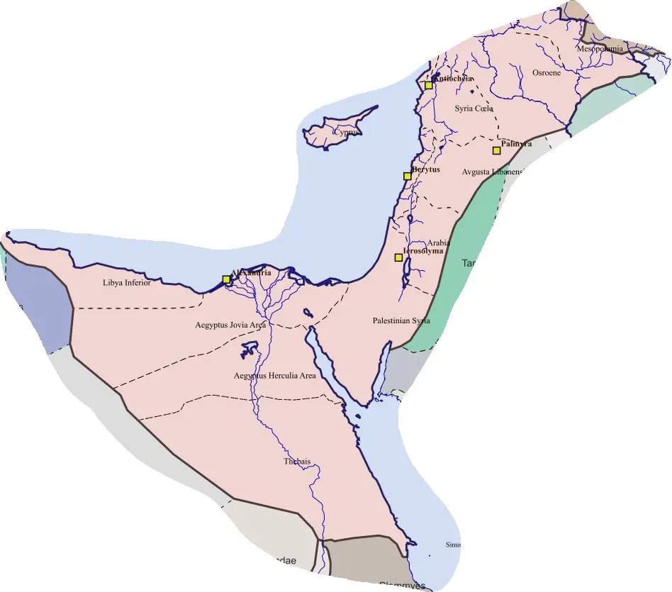
Cyprus
The island’s ports, farming, copper districts, towns, and religious institutions continued within a separate province. Constantia’s…
- AEGYPTVSLE-56LE-56
Aegyptus
The late province retained the empire’s great Egyptian port and an exceptionally influential Christian centre. Grain collection and…
- AVGVSTAMNICALE-57LE-57
Augustamnica
The province’s fields, waterways, towns, and routes connected Nile production with Mediterranean and eastern approaches. Pelusium occupied…
- ARCADIALE-58LE-58
Arcadia
The province’s name commemorated imperial association rather than a connection with the Greek Peloponnesian region of Arcadia. Its towns…
- THEBAISLE-59LE-59
Thebais
The long river corridor connected cultivated fields, towns, villages, quarries, desert routes, and southern approaches. Temple traditions…
- LIBYA SVPERIORLE-60LE-60
Libya Superior
The province inherited Greek cities, productive uplands, ports, and relationships with inland communities. Agriculture, livestock, regional…
- LIBYA INFERIORLE-61LE-61
Libya Inferior
The province occupied a more arid and sparsely urbanized environment than the Cyrenaican uplands. Coastal movement, local cultivation where…
Earlier divisions, temporary arrangements, and the final ancient reorganizations 26
Some provincial identities belong between the major dossiers and the late provincial system. Others emerged after the late fourth-century pattern had already changed. These histories require their own profiles because a single name can conceal the replacement of one jurisdiction by another.
- HISPANIA CITERIOR VNDER THE REPVBLICAH-01AH-01
Hispania Citerior under the Republic
The nearer Spanish command developed from Rome’s wartime footholds against Carthage. Tarraco and the Mediterranean approaches gave it…
- HISPANIA VLTERIOR VNDER THE REPVBLICAH-02AH-02
Hispania Ulterior under the Republic
The further Spanish command combined established southern cities with territories conquered through repeated campaigns farther west. The…
- AFRICA VETVSAH-03AH-03
Africa Vetus
The old province occupied only part of Carthage’s former sphere. Its towns, farming districts, Punic traditions, and Roman public land…
 AH-04
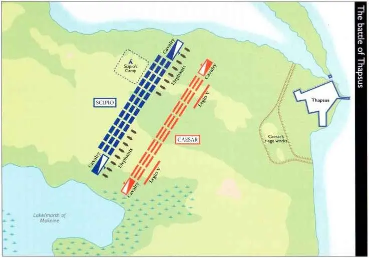
Africa Nova
Africa Nova was created through the convergence of Roman civil war and the destruction of a regional monarchy. It placed newly annexed…
- DACIA SVPERIORAH-05AH-05
Dacia Superior
Dacia Superior governed important parts of the occupied territory beyond the Danube while other districts received separate arrangements.…
- DACIA INFERIORAH-06AH-06
Dacia Inferior
The lower province addressed practical problems of communication, garrisoning, and government in territories distinct from the principal…
- DACIA POROLISSENSISAH-07AH-07
Dacia Porolissensis
Porolissensis gave a distinct administrative identity to districts controlling northern and northwestern approaches. Forts, roads…
- DACIA APVLENSISAH-08AH-08
Dacia Apulensis
Apulensis occupied a leading position within the Three Dacias. The Apulum complex joined legionary, civilian, commercial, religious, and…
- DACIA MALVENSISAH-09AH-09
Dacia Malvensis
Malvensis is a genuine provincial name whose geographical reconstruction remains difficult. Its likely southern associations and possible…
- THE SHORT-LIVED HISPANIA NOVA CITERIOR ANTONINIANAAH-10AH-10
The short-lived Hispania Nova Citerior Antoniniana
The name represents an intermediate attempt to differentiate northern Hispanic administration. Its relationship to the later province of…
- THEODORIASAH-11AH-11
Theodorias
Theodorias was a Justinianic Syrian province created from coastal cities and their territories detached from neighbouring jurisdictions.…
- JVSTINIAN’S ARMENIA PRIMAAH-12AH-12
Justinian’s Armenia Prima
The new first province reorganized interior and northeastern territories, incorporating cities from earlier Armenian and Pontic…
- JVSTINIAN’S ARMENIA SECVNDAAH-13AH-13
Justinian’s Armenia Secunda
The new numbering moved an established provincial centre into a different place within the Armenian system. Sebasteia’s urban and…
- JVSTINIAN’S ARMENIA TERTIAAH-14AH-14
Justinian’s Armenia Tertia
The province continued a long military and urban history around the upper Euphrates. Its new governor held an enhanced title and…
- JVSTINIAN’S ARMENIA QVARTAAH-15AH-15
Justinian’s Armenia Quarta
The province brought territories with different local authorities into a more ordinary Roman civil framework. This was a significant…
- AEGYPTVS PRIMAAH-16AH-16
Aegyptus Prima
The numbered province belonged to a stage later than the first separation of Aegyptus from other Egyptian jurisdictions. Alexandria’s grain…
- AEGYPTVS SECVNDAAH-17AH-17
Aegyptus Secunda
Its existence reflects the pressure to divide responsibilities within a densely cultivated and institutionally complex region. Villages…
- AVGVSTAMNICA PRIMAAH-18AH-18
Augustamnica Prima
The province combined cultivation, waterways, towns, routes, and strategic approaches towards the east. Pelusium’s position made security…
- AVGVSTAMNICA SECVNDAAH-19AH-19
Augustamnica Secunda
This province’s history rested on cultivated land, canals, settlements, local legal relationships, and the officials responsible for…
- THEBAIS INFERIORAH-20AH-20
Thebais Inferior
The province followed the Nile through towns, cultivated districts, villages, estates, and religious centres. Its creation narrowed a…
 AH-21
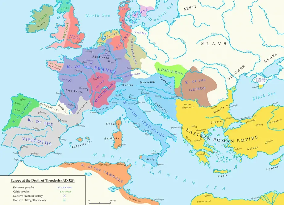
Thebais Superior
The province combined Nile cultivation with southern approaches, desert routes, quarries, religious centres, and military concerns.…
- SPANIAAH-22AH-22
Spania: the Eastern Roman province in Iberia
The province emerged from imperial intervention in Visigothic political conflict. Its holdings included important ports and coastal…
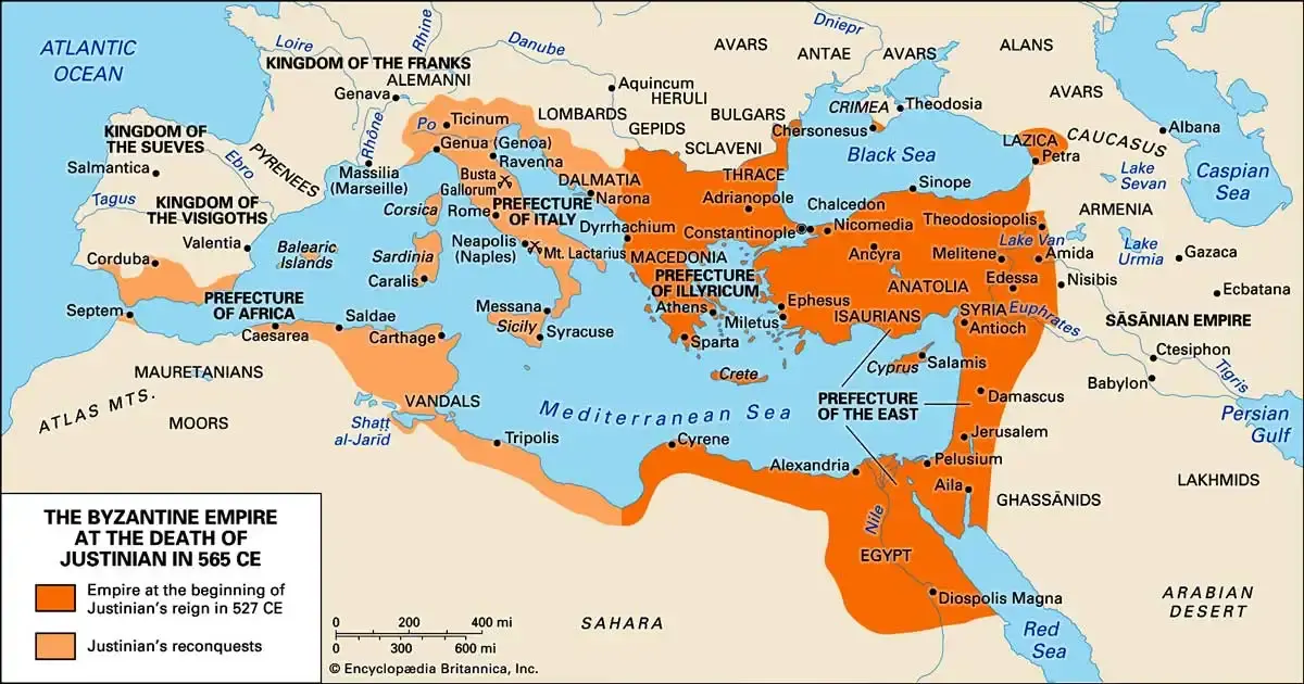 AH-23
The restored African provincial system
The conquest of the Vandal kingdom restored direct Roman government to important North African territories and associated islands. Imperial…
 AH-24
The restored Italian provinces
Justinian’s conquest of Ostrogothic Italy restored imperial sovereignty through a long and destructive war. The recovery included repeated…
- THE QVAESTVRA EXERCITVSAH-25AH-25
The quaestura exercitus
The arrangement connected lower Danubian military needs with the resources of maritime and southern provinces. Moesia Secunda and Scythia…
- NVMIDIA CIRTENSIS AND NVMIDIA MILITIANAAH-26AH-26
Numidia Cirtensis and Numidia Militiana
The northern Cirtan and military-associated designations expressed an attempt to differentiate administrative responsibilities within a…
Royal territories and provincial borderlands 8
Roman power extended beyond ordinary provinces. Allied and dependent rulers could recognize imperial supremacy, receive appointments or subsidies, provide soldiers, and admit garrisons while retaining a kingdom’s institutions. Annexation might later absorb that territory into a neighbouring province rather than create a new province bearing the kingdom’s name.
- COMMAGENERB-01RB-01
Commagene
Commagene occupied a strategic position near the upper Euphrates, where crossings and routes linked Anatolia, Syria, and the Armenian…
- PONTVS POLEMONIACVS BEFORE THE LATE PROVINCERB-02RB-02
Pontus Polemoniacus before the late province
The Polemonian realm belonged to the succession of royal arrangements created and maintained after the Mithridatic wars. Its rulers…
- LESSER ARMENIARB-03RB-03
Lesser Armenia
Lesser Armenia’s rulers and communities occupied a strategic intermediary zone. Roman settlements after the Mithridatic wars used dependent…
- THE BOSPORAN KINGDOMRB-04RB-04
The Bosporan kingdom
The Bosporan kingdom combined Greek cities, royal institutions, agricultural territories, ports, and relationships with neighbouring steppe…
- CHALCIS AND THE HERODIAN DYNASTIC TERRITORIESRB-05RB-05
Chalcis and the Herodian dynastic territories
The name Chalcis appears within a complicated history of dynastic territories whose boundaries and rulers changed. Herodian princes could…
- CHARACENE AND THE HEAD OF THE PERSIAN GVLFRB-06RB-06
Characene and the head of the Persian Gulf
Characene connected river systems and maritime exchange near the head of the Persian Gulf. Its ports and rulers participated in networks…
- ADIABENERB-07RB-07
Adiabene
Adiabene’s rulers and communities participated in eastern political networks long before Trajan. Its agricultural districts, towns, roads…
- COLCHIS, LAZICA, AND CAVCASIAN IBERIARB-08RB-08
Colchis, Lazica, and Caucasian Iberia
These lands occupied the approaches between the Black Sea, mountain corridors, and the wider Caucasian world. Local rulers, fortresses…
Go further: the guides
The compendium's own chapters on how to read the entries, and the world around them.