Provinces · Gaul and the Rhine
RP-11 Gallia Belgica
An expansive northeastern society
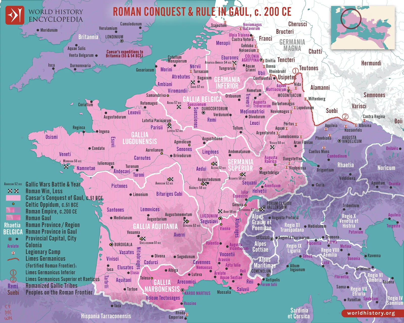
Belgica connected the Paris basin and northern Gaul to the Rhine and North Sea. Its settlements ranged from inland civic centres to coastal and riverine communities. Fertile agricultural districts, forests, wetlands, and transport routes gave the region several economic orientations. The province’s name preserved a Roman ethnographic category while encompassing a wider range of communities than any modern national label suggests.
Caesar’s campaigns involved alliances as well as destruction. The Remi’s relationship with Rome differed from that of communities subjected to punitive conquest. The Nervii, Eburones, Treveri, and other peoples occupied distinct political and geographical settings. Their later incorporation into provincial society did not make the preceding violence unimportant or their postconquest trajectories identical.
Reims, Trier, and the Rhine connection
Durocortorum developed as a major administrative and road centre. Augusta Treverorum occupied a powerful position on the Moselle, connecting inland routes to the Rhine system. Towns such as Divodurum, Samarobriva, and Bagacum organized additional civic territories. A governor’s seat mattered, but the province depended on this broader web of local administration.
Before the Germanies became territorial provinces, Rhine armies stood within a more complicated relationship to Belgic geography and command. Their separation changed Belgica’s borders and military responsibilities. Even afterward, the civilian province remained closely tied to supplying frontier communities. Grain, livestock, textiles, transport services, and manufactured goods crossed administrative boundaries that did not interrupt economic relationships.
Economy, status, and cultural change
Large rural establishments and smaller farms supported an agricultural surplus, while pottery centres and workshops supplied regional and military markets. Roads connected towns to the Channel, Rhine, and neighbouring provinces. Coins, imported goods, and changing rural architecture indicate participation in wider exchange, but access to these benefits varied between communities and households.
Latin became prominent in public inscriptions and administration. Local divine names and regional cults continued, often represented in Roman forms. The religious world included healing sanctuaries, civic temples, household worship, and cults spread by mobile populations. Christianity later developed through urban and military connections, creating bishoprics that helped preserve the importance of older towns.
Trier and the late imperial north
Trier’s growth into an imperial residence transformed its relationship to the wider state. Palace buildings, administrative activity, military movement, and the presence of the court created demand and political importance beyond the scale of an ordinary city. The Moselle landscape surrounding it supported elite residences and productive estates, while its urban institutions adapted to repeated changes in imperial power.
Belgica Prima and Secunda represented a later division of the remaining province. Trier and Reims retained major positions, but neither jurisdiction was insulated from the wars and settlements along the frontier. Frankish groups entered Roman service, settled within imperial territories, fought Roman forces, and eventually established royal power. These relationships developed over generations. The transition from Roman Belgica to Frankish rule therefore involved both conflict and the reuse of Roman offices, towns, religious institutions, and political expectations.
Settlement geography
| Ancient place | Modern location |
|---|---|
| Durocortorum | Reims |
| Augusta Treverorum | Trier, Germany |
| Divodurum | Metz |
| Samarobriva | Amiens |
| Bagacum | Bavay |
| Gesoriacum | Boulogne-sur-Mer |